Error message
- Deprecated function: Return type of DateObject::__wakeup() should either be compatible with DateTime::__wakeup(): void, or the #[\ReturnTypeWillChange] attribute should be used to temporarily suppress the notice in include_once() (line 143 of /home1/msr/public_html/sites/all/modules/date/date_api/date_api.module).
- Deprecated function: Return type of DateObject::format($format, $force = false) should either be compatible with DateTime::format(string $format): string, or the #[\ReturnTypeWillChange] attribute should be used to temporarily suppress the notice in include_once() (line 143 of /home1/msr/public_html/sites/all/modules/date/date_api/date_api.module).
- Deprecated function: Return type of DateObject::setTimezone($tz, $force = false) should either be compatible with DateTime::setTimezone(DateTimeZone $timezone): DateTime, or the #[\ReturnTypeWillChange] attribute should be used to temporarily suppress the notice in include_once() (line 143 of /home1/msr/public_html/sites/all/modules/date/date_api/date_api.module).
- Deprecated function: Creation of dynamic property views_plugin_display_default::$is_plugin is deprecated in DrupalDatabaseCache->prepareItem() (line 449 of /home1/msr/public_html/includes/cache.inc).
- Deprecated function: Creation of dynamic property views_display::$vid is deprecated in DrupalDatabaseCache->prepareItem() (line 449 of /home1/msr/public_html/includes/cache.inc).
- Deprecated function: Creation of dynamic property views_display::$id is deprecated in DrupalDatabaseCache->prepareItem() (line 449 of /home1/msr/public_html/includes/cache.inc).
- Deprecated function: Creation of dynamic property views_display::$display_title is deprecated in DrupalDatabaseCache->prepareItem() (line 449 of /home1/msr/public_html/includes/cache.inc).
- Deprecated function: Creation of dynamic property views_display::$display_plugin is deprecated in DrupalDatabaseCache->prepareItem() (line 449 of /home1/msr/public_html/includes/cache.inc).
- Deprecated function: Creation of dynamic property views_display::$position is deprecated in DrupalDatabaseCache->prepareItem() (line 449 of /home1/msr/public_html/includes/cache.inc).
- Deprecated function: Creation of dynamic property views_plugin_display_page::$is_plugin is deprecated in DrupalDatabaseCache->prepareItem() (line 449 of /home1/msr/public_html/includes/cache.inc).
- Deprecated function: Creation of dynamic property views_plugin_display_page::$default_display is deprecated in DrupalDatabaseCache->prepareItem() (line 449 of /home1/msr/public_html/includes/cache.inc).
- Deprecated function: Creation of dynamic property views_display::$vid is deprecated in DrupalDatabaseCache->prepareItem() (line 449 of /home1/msr/public_html/includes/cache.inc).
- Deprecated function: Creation of dynamic property views_display::$id is deprecated in DrupalDatabaseCache->prepareItem() (line 449 of /home1/msr/public_html/includes/cache.inc).
- Deprecated function: Creation of dynamic property views_display::$display_title is deprecated in DrupalDatabaseCache->prepareItem() (line 449 of /home1/msr/public_html/includes/cache.inc).
- Deprecated function: Creation of dynamic property views_display::$display_plugin is deprecated in DrupalDatabaseCache->prepareItem() (line 449 of /home1/msr/public_html/includes/cache.inc).
- Deprecated function: Creation of dynamic property views_display::$position is deprecated in DrupalDatabaseCache->prepareItem() (line 449 of /home1/msr/public_html/includes/cache.inc).
- Deprecated function: Creation of dynamic property view::$export_module is deprecated in DrupalDatabaseCache->prepareItem() (line 449 of /home1/msr/public_html/includes/cache.inc).
- Deprecated function: Creation of dynamic property view::$type is deprecated in ctools_export_load_object() (line 537 of /home1/msr/public_html/sites/all/modules/ctools/includes/export.inc).
- Deprecated function: Creation of dynamic property view::$export_type is deprecated in ctools_export_load_object() (line 538 of /home1/msr/public_html/sites/all/modules/ctools/includes/export.inc).
- Deprecated function: Creation of dynamic property view::$in_code_only is deprecated in ctools_export_load_object() (line 539 of /home1/msr/public_html/sites/all/modules/ctools/includes/export.inc).
- Deprecated function: Creation of dynamic property view::$table is deprecated in ctools_export_load_object() (line 540 of /home1/msr/public_html/sites/all/modules/ctools/includes/export.inc).
- Deprecated function: Creation of dynamic property views_plugin_display_default::$is_plugin is deprecated in _views_create_handler() (line 59 of /home1/msr/public_html/sites/all/modules/views/includes/handlers.inc).
- Deprecated function: Creation of dynamic property views_plugin_display_default::$localization_keys is deprecated in view->init_display() (line 462 of /home1/msr/public_html/sites/all/modules/views/includes/view.inc).
- Deprecated function: Creation of dynamic property views_plugin_display_page::$is_plugin is deprecated in _views_create_handler() (line 59 of /home1/msr/public_html/sites/all/modules/views/includes/handlers.inc).
- Deprecated function: Creation of dynamic property views_plugin_display_page::$localization_keys is deprecated in view->init_display() (line 462 of /home1/msr/public_html/sites/all/modules/views/includes/view.inc).
- Deprecated function: Creation of dynamic property views_plugin_display_page::$default_display is deprecated in view->init_display() (line 470 of /home1/msr/public_html/sites/all/modules/views/includes/view.inc).
- Deprecated function: Creation of dynamic property view::$relationships_fixed is deprecated in view->fix_missing_relationships() (line 589 of /home1/msr/public_html/sites/all/modules/views/includes/view.inc).
- Deprecated function: Creation of dynamic property views_handler_field_date::$is_handler is deprecated in _views_create_handler() (line 55 of /home1/msr/public_html/sites/all/modules/views/includes/handlers.inc).
- Deprecated function: Creation of dynamic property views_handler_field_date::$localization_keys is deprecated in views_handler->init() (line 223 of /home1/msr/public_html/sites/all/modules/views/includes/handlers.inc).
- Deprecated function: Creation of dynamic property views_plugin_localization_none::$is_plugin is deprecated in _views_create_handler() (line 59 of /home1/msr/public_html/sites/all/modules/views/includes/handlers.inc).
- Deprecated function: Creation of dynamic property view::$localization_plugin is deprecated in view->init_localization() (line 2093 of /home1/msr/public_html/sites/all/modules/views/includes/view.inc).
- Deprecated function: Creation of dynamic property views_handler_field_date::$table is deprecated in views_handler->init() (line 234 of /home1/msr/public_html/sites/all/modules/views/includes/handlers.inc).
- Deprecated function: Creation of dynamic property views_handler_field_date::$field is deprecated in views_handler->init() (line 246 of /home1/msr/public_html/sites/all/modules/views/includes/handlers.inc).
- Deprecated function: Creation of dynamic property views_handler_field_date::$is_handler is deprecated in _views_create_handler() (line 55 of /home1/msr/public_html/sites/all/modules/views/includes/handlers.inc).
- Deprecated function: Creation of dynamic property views_handler_field_date::$localization_keys is deprecated in views_handler->init() (line 223 of /home1/msr/public_html/sites/all/modules/views/includes/handlers.inc).
- Deprecated function: Creation of dynamic property views_handler_field_date::$table is deprecated in views_handler->init() (line 234 of /home1/msr/public_html/sites/all/modules/views/includes/handlers.inc).
- Deprecated function: Creation of dynamic property views_handler_field_date::$field is deprecated in views_handler->init() (line 246 of /home1/msr/public_html/sites/all/modules/views/includes/handlers.inc).
- Deprecated function: Creation of dynamic property feeds_views_handler_field_log_message::$is_handler is deprecated in _views_create_handler() (line 55 of /home1/msr/public_html/sites/all/modules/views/includes/handlers.inc).
- Deprecated function: Creation of dynamic property feeds_views_handler_field_log_message::$localization_keys is deprecated in views_handler->init() (line 223 of /home1/msr/public_html/sites/all/modules/views/includes/handlers.inc).
- Deprecated function: Creation of dynamic property feeds_views_handler_field_log_message::$table is deprecated in views_handler->init() (line 234 of /home1/msr/public_html/sites/all/modules/views/includes/handlers.inc).
- Deprecated function: Creation of dynamic property feeds_views_handler_field_log_message::$field is deprecated in views_handler->init() (line 246 of /home1/msr/public_html/sites/all/modules/views/includes/handlers.inc).
- Deprecated function: Creation of dynamic property feeds_views_handler_field_severity::$is_handler is deprecated in _views_create_handler() (line 55 of /home1/msr/public_html/sites/all/modules/views/includes/handlers.inc).
- Deprecated function: Creation of dynamic property feeds_views_handler_field_severity::$localization_keys is deprecated in views_handler->init() (line 223 of /home1/msr/public_html/sites/all/modules/views/includes/handlers.inc).
- Deprecated function: Creation of dynamic property feeds_views_handler_field_severity::$table is deprecated in views_handler->init() (line 234 of /home1/msr/public_html/sites/all/modules/views/includes/handlers.inc).
- Deprecated function: Creation of dynamic property feeds_views_handler_field_severity::$field is deprecated in views_handler->init() (line 246 of /home1/msr/public_html/sites/all/modules/views/includes/handlers.inc).
- Deprecated function: Creation of dynamic property views_handler_argument_numeric::$is_handler is deprecated in _views_create_handler() (line 55 of /home1/msr/public_html/sites/all/modules/views/includes/handlers.inc).
- Deprecated function: Creation of dynamic property views_handler_argument_numeric::$localization_keys is deprecated in views_handler->init() (line 223 of /home1/msr/public_html/sites/all/modules/views/includes/handlers.inc).
- Deprecated function: Creation of dynamic property views_handler_argument_numeric::$table is deprecated in views_handler->init() (line 234 of /home1/msr/public_html/sites/all/modules/views/includes/handlers.inc).
- Deprecated function: Creation of dynamic property views_handler_argument_numeric::$field is deprecated in views_handler->init() (line 246 of /home1/msr/public_html/sites/all/modules/views/includes/handlers.inc).
- Deprecated function: Creation of dynamic property views_handler_sort::$is_handler is deprecated in _views_create_handler() (line 55 of /home1/msr/public_html/sites/all/modules/views/includes/handlers.inc).
- Deprecated function: Creation of dynamic property views_handler_sort::$localization_keys is deprecated in views_handler->init() (line 223 of /home1/msr/public_html/sites/all/modules/views/includes/handlers.inc).
- Deprecated function: Creation of dynamic property views_handler_sort::$table is deprecated in views_handler->init() (line 234 of /home1/msr/public_html/sites/all/modules/views/includes/handlers.inc).
- Deprecated function: Creation of dynamic property views_handler_sort::$field is deprecated in views_handler->init() (line 246 of /home1/msr/public_html/sites/all/modules/views/includes/handlers.inc).
- Deprecated function: Creation of dynamic property feeds_views_handler_filter_severity::$is_handler is deprecated in _views_create_handler() (line 55 of /home1/msr/public_html/sites/all/modules/views/includes/handlers.inc).
- Deprecated function: Creation of dynamic property feeds_views_handler_filter_severity::$value_title is deprecated in views_handler_filter_in_operator->construct() (line 28 of /home1/msr/public_html/sites/all/modules/views/handlers/views_handler_filter_in_operator.inc).
- Deprecated function: Creation of dynamic property feeds_views_handler_filter_severity::$localization_keys is deprecated in views_handler->init() (line 223 of /home1/msr/public_html/sites/all/modules/views/includes/handlers.inc).
- Deprecated function: Creation of dynamic property feeds_views_handler_filter_severity::$table is deprecated in views_handler->init() (line 234 of /home1/msr/public_html/sites/all/modules/views/includes/handlers.inc).
- Deprecated function: Creation of dynamic property feeds_views_handler_filter_severity::$field is deprecated in views_handler->init() (line 246 of /home1/msr/public_html/sites/all/modules/views/includes/handlers.inc).
- Deprecated function: Creation of dynamic property views_handler_area_text::$is_handler is deprecated in _views_create_handler() (line 55 of /home1/msr/public_html/sites/all/modules/views/includes/handlers.inc).
- Deprecated function: Creation of dynamic property views_handler_area_text::$localization_keys is deprecated in views_handler->init() (line 223 of /home1/msr/public_html/sites/all/modules/views/includes/handlers.inc).
- Deprecated function: Creation of dynamic property views_handler_area_text::$table is deprecated in views_handler->init() (line 234 of /home1/msr/public_html/sites/all/modules/views/includes/handlers.inc).
- Deprecated function: Creation of dynamic property views_handler_area_text::$field is deprecated in views_handler->init() (line 246 of /home1/msr/public_html/sites/all/modules/views/includes/handlers.inc).
- Deprecated function: Creation of dynamic property view::$inited is deprecated in view->init_handlers() (line 674 of /home1/msr/public_html/sites/all/modules/views/includes/view.inc).
- Deprecated function: Creation of dynamic property feeds_views_plugin_argument_validate_feed_nid::$is_plugin is deprecated in _views_create_handler() (line 59 of /home1/msr/public_html/sites/all/modules/views/includes/handlers.inc).
- Deprecated function: Creation of dynamic property feeds_views_plugin_argument_validate_feed_nid::$argument is deprecated in views_plugin_argument_validate->init() (line 27 of /home1/msr/public_html/sites/all/modules/views/plugins/views_plugin_argument_validate.inc).
- Deprecated function: Creation of dynamic property views_handler_argument_numeric::$argument_validated is deprecated in views_handler_argument->validate_arg() (line 989 of /home1/msr/public_html/sites/all/modules/views/handlers/views_handler_argument.inc).
Forecast continuity - or the lack thereof...
Anchored off Motuarohia, Bay of Islands
Spending the South Pacific Cyclone Season in New Zealand
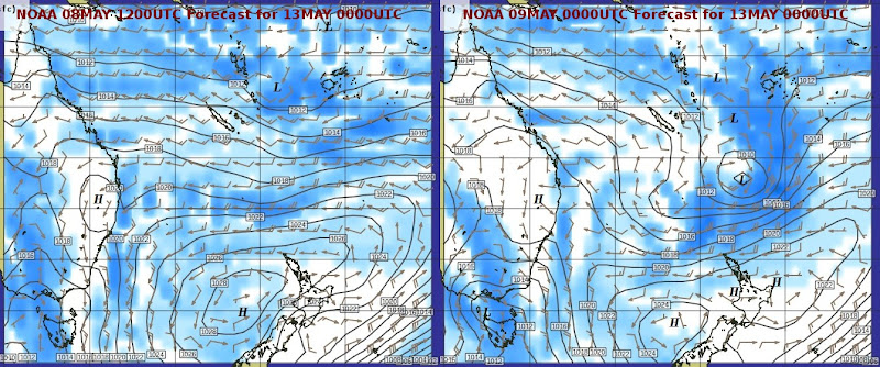
As an illustration why that weather window mentioned in the previous post has so far been elusive... The image on the left above shows a computer model forecast (NOAA GFS) from this morning, valid for next Monday. That forecast made a Saturday/Sunday departure look favorable with good conditions along the way. The image shows isobars, wind arrows (each full barb representing 10kn), and blue shading indicates rain intensity.
The image on the right is also valid for next Monday but shows the model forecast from this evening, 12 hours more recent. This one shows a related but very different picture. What has been a shallow undefined area of low pressure west of Fiji in this morning's forecast (and projected to move off to the east and dissipate) has turned into a well formed depression on it's way south in this evening's forecast (and projected to further intensify over the following 24 hours). No longer a favorable departure window...but of course things may all be changed by tomorrow morning again ;-)
What this probably shows is the difficulty of forecasting even a rough outline of weather developments beyond 72 hours in this part of the world as long as the South Pacific Convergence Zone is active. The only things that can probably be gleaned from the longer term model output is the lack of confidence/instability indicated by the significant differences in results from successive model runs.
So we may be in for a few more days in the Bay of Islands until things settle down a bit. Not a bad spot to be in in any case...
Add new comment